Southwark was medieval Londons first suburb and the pleasure quarter of Tudor and Stuart London. The Bankside (the street along the river) was lined with brothels or stewhouses and bull and bear pits. There were four theatres in the area during the Shakespearean period. Patrons from London got to Southwark by walking over London Bridge or taking a ferry (cost: one penny) to St. Mary Overies Stairs, Bank End Stairs, or Paris Garden Stairs.
Walk East along the Thames River Path to Blackfriars Bridge. London Bridge was the only footway across the Thames until Blackfriars was opened in 1769. Blackfriars takes its name from the Blackfriars Monastery that was dissolved by Henry VIII in 1538. In the late 16th century it became the site for rehearsals of a children's playing company. In 1596 James Burbage opened his Blackfriars Theatre in another part of the monastery, performing plays by Shakespeare, Beaumont, and Fletcher. Henry VIII had a palace (Bridewell Place) nearby (where the Unilever House is now), and received Charles V there in 1522. His son Edward VI gave Bridewell to the City of London which converted it into an orphanage. In 1619, 200 orphans from Bridewell were sent to help populate the new colony of Virginia. Its surrounding taverns were frequented by Chaucer, Shakespeare, and Milton. Further to the Northeast was the center of the early printing industry. In 1500 Wynkyn de Worde moved Caxton's presses from Westminster to Fleet Street in St. Bride's parish, and by the time of his death in 1535, a number of printers had relocated in the area.
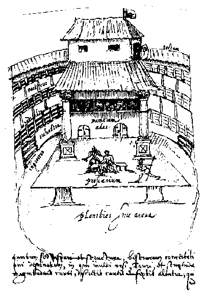
Walk along the bankside to the reconstructed Globe Theatre. Because Southwark was out of the jurisdiction of the City of London, there were fewer restrictions on activities. The first theatre known to have existed on the South Bank was The Rose. Built in 1587 by Philip Henslowe, it was the site of performances of plays by both Shakespeare (Titus Andronicus and Henry VI) and Marlowe (Dr. Faustus, Tamburlain the Great, and The Jew of Malta). The Swan, built in 1594 by Francis
 Langley
in what was then called Paris Garden, featured Marlowes plays. The
Globe was built in 1599 (using timber from a 1576 theatre in
Shoreditch) near what is now Park Street. Its construction was funded by
the Lord Chamberlains Men, a company of actors which included Shakespeare.
Shakespeares plays Hamlet, King Lear, Macbeth,
and Othello were all written for The
Globe. The theatre burned down in 1613 during a performance
of Shakespeares Henry VIII and later rebuilt. The
Hope was converted from a bear and bull baiting arena to a theatre
shortly after The Globe burned down.
The first performance of Ben Jonsons
Bartholomew Fair occurred
here in 1614. All the playhouses were closed down by the Puritans
in 1642.
Langley
in what was then called Paris Garden, featured Marlowes plays. The
Globe was built in 1599 (using timber from a 1576 theatre in
Shoreditch) near what is now Park Street. Its construction was funded by
the Lord Chamberlains Men, a company of actors which included Shakespeare.
Shakespeares plays Hamlet, King Lear, Macbeth,
and Othello were all written for The
Globe. The theatre burned down in 1613 during a performance
of Shakespeares Henry VIII and later rebuilt. The
Hope was converted from a bear and bull baiting arena to a theatre
shortly after The Globe burned down.
The first performance of Ben Jonsons
Bartholomew Fair occurred
here in 1614. All the playhouses were closed down by the Puritans
in 1642.
Walk East toward Southwark Bridge (built in 1819). Take the path under the bridge to Clink Street, the site of Winchester Palace and the Clink (the bishops prison). Winchester Palace, built in the 12th century, was the London residence of the Bishop of Winchester. All that remains of the palace is the 14th century Rose Window which was part of the Great Hall. Because the Bankside area was under the jurisdiction of the Bishop of Winchester, he was responsible for maintaining law and order in the area. The bishops licensed the prostitutes who worked in the stews (thus, their nickname: Winchester Geese) and regulated the inns in the vicinity, imprisoning offenders in The Clink. During the 16th century, the prison housed both Protestant and Catholic heretics. The Clink was one of several jails located in Southwark. The Marshalsea was the second most important prison after the Tower in the Elizabethan era; it mainly housed debtors (Charles Dickens father was imprisoned there in 1824). The Kings Bench, a prison located near Borough High Street, kept a number of the Marian martyrs but was primarily used for debtors.
Continue walking East to St. Mary Overie Dock which now incorporates a replica of the Elizabethan galleon, the Golden Hind. Originally named the Pelican, the 16th century-ship was captained by Francis Drake and set sail on a voyage into the unknown in 1577. It was renamed the Golden Hind near the Straights of Magellan. Drake chose the name from the hind on the armorial of Sir Christopher Hatton, an Elizabethan courtier and the expeditions sponsor. When the ship returned to England after its voyage around the world, it was visited by Queen Elizabeth who congratulated the crew and knighted Drake in 1581.
Go South to Southwark Cathedral, which contains a chapel to John Harvard, the founder of Harvard University. Harvard was born in Southwark in 1607 and baptized in what was then known as St. Saviours Church. His mother owned the Queens Head Inn on nearby Borough High Street. The cathedral is also the burial place of Shakespeares brother Edmund (died 1607), a member of the Southwark players, and of Jacobean dramatists John Fletcher (died 1625) and Philip Massinger (died 1640). The cathedral was originally the church of the Augustinian Priory of St. Mary Overie and became the parish church of St. Saviour in 1540 after Henry VIII dissolved the monasteries (it did not become a cathedral until 1905). A stone Tudor screen separates the choir and retrochoir, the oldest Gothic structures extant in London. There is a memorial to Shakespeare in the south aisle.
Borough High Street which heads South from London Bridge was the main southern thoroughfare out of the City (London Bridge was the only bridge over the Thames until the 18th century) and was consequently the location of numerous inns. Chaucers Canterbury pilgrims set off from the Tabard Inn on Borough High Street. Several blocks South of the river is Queens Head Yard, the original site of Marshalsea Prison, and, further South, the 16th century palace of Charles Brandon, Duke of Suffolk, who married Henry VIIIs sister, Mary. Suffolk Place, as the palace was called, was later taken over by the king and used as a mint (giving its name to the nearby street).
Walk North on Borough High Street to St. Thomas Street. This was the location of St. Thomas Hospital, founded in the 13th century as part of the Priory of St. Mary Overie. The first printed Bible in English was produced by James Nicholson at St. Thomas Hospital in 1527. The nearby streets housed the shops and homes of Elizabethan craftsmen, who settled in the area to avoid the restrictions imposed by the City of Londons guilds. Glaziers, leather workers, printers, potter makers, brewers, and sculptors were all located in the area. The Miller in Chaucers Canterbury Tales, for example, talks about having too much Southwark ale.
 Continue North
on Borough High Street to London Bridge.
During the Elizabethan and Jacobean periods the bridge was lined with houses
and shops and contained a drawbridge on its southern side. The gatehouses
on either end of the bridge were closed every night, and travelers who
did not make it across in time were forced to spend the night in one of
the inns. Traitors heads were posted on the gateposts (including
that of Thomas More in 1535). Not until the 18th century were the houses
removed and the roadway widened.
Continue North
on Borough High Street to London Bridge.
During the Elizabethan and Jacobean periods the bridge was lined with houses
and shops and contained a drawbridge on its southern side. The gatehouses
on either end of the bridge were closed every night, and travelers who
did not make it across in time were forced to spend the night in one of
the inns. Traitors heads were posted on the gateposts (including
that of Thomas More in 1535). Not until the 18th century were the houses
removed and the roadway widened.